Wednesday, February 6, 2013

Tarpon Springs


The region, with a series of bayous feeding into the Gulf of Mexico, first attracted attention as a place for winter homes about 1876. Some of the newly arrived visitors spotted tarpons jumping out of the waters and so named the location Tarpon Springs. The first Greek immigrants arrived to this city during the 1880s, when they were hired to work as divers in the growing sponge harvesting industry.


In 1905, John Cocoris introduced the technique of sponge diving to Tarpon Springs. Cocoris recruited Greek sponge divers from the Dodecanese Islands of Greece, in particular Kalymnos, Symi and Halki leading, by the 1930s, to a very productive sponge industry in Tarpon Springs, generating millions of dollars a year.


The 1953 film Beneath the 12-Mile Reef, depicting sponge diving, takes place and was filmed in Tarpon Springs.


When a red tide algae bloom occurred in 1947, wiping out the sponge fields in that region of the Gulf of Mexico.


Most of the sponge boats and divers switched to fishing and shrimping for a livelihood. The city then converted most of its sponge-related activities, especially the warehouses where they were sold, into tourist attractions.


The Sponge Docks are now mostly shops, restaurants, and museums dedicated to the memory of Tarpon Springs' earlier industry.


Most sponges sold on the docks are now imports; relatively few sponges are harvested from the area, although attempts have been made in recent years to restart local sponge harvesting.


There are many restaurants serving traditional Greek cuisine and fresh seafood that dot the street as well as quaint boutiques that sell everything from real sponges to imported goods.


We met up with fellow loopers at Hella's Restaurant for a fun filled evening of some of the best Greek food in town.


Hella's Restaurant offers many appetizers and entrĂ©es and passed down family recipes. Our courteous waiter was happy to suggest the best appetizer in the house, Saganaki (Flaming imported Greek cheese).


OPA!
 

Bob dug into his lamb and beef Gyro Special and I had Hella's Grouper, which was to die for! We ate our way through Tarpon Springs.


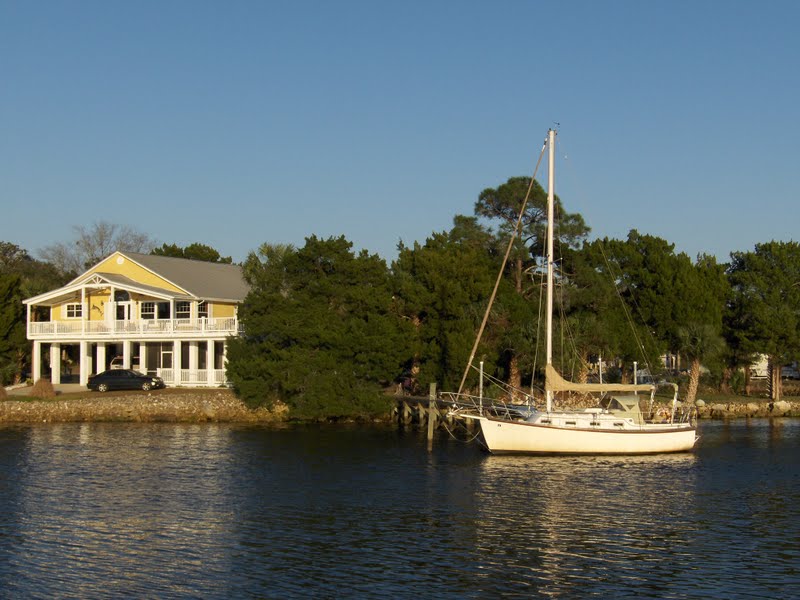
We stayed at a lovely, quiet marina called Turtle Cove off the main channel, where crab boats passed us daily at sunrise and sundown each day. 


This was such a nice place to be, we stayed here two weeks, and ate, and ate, and ate. We are leaving tomorrow to go explore St. Petersburg. What a life.
 

Saturday, January 26, 2013

Old Florida


Along the west coast shoreline of the Big Bend, the Gulf of Mexico is relatively shallow and the coastline low and marshy. Fishing camp towns and facilities that cater to cruising boats are beginning to open  along the many shallow rivers and creeks.


The countryside is still undeveloped , even primitive in spots. This is Old Florida.


We enter the Withlacoochee River, which is north of Crystal River and is one of the very few rivers in the world that flow south to north. It is a pristine river with wonderful views of Cypress trees and an abundance of wildlife.


Traveling close behind us is Kurt and Pat on Krazy Kru, as we navigate, following the depth sounder, wary of the shoal waters as the sun is setting quickly.


You will see Eagles, Osprey, Hawks, King Fishers, Alligators, Turtles and much more. It is also a great River to catch Bass, Specs, Stump Knockers and Catfish.


These are fisherman's waters, both fresh and saltwater. The rivers are shallow and tricky, but the benefits are glorious coasting through the most pristeen Florida wilderness that time has forgotten.


The Withlacoochee River originates in central Florida’s Green Swamp. It flows west, then north, and then turns northwest and finally west again before it empties into the Gulf of Mexico in Yankeetown.


"Withlacoochee" is probably compounded of Creek we (water), thlako (big), and chee (little), or little big water. This word combination signifies little great river in the Creek language.


The Withlacoochee River is one of Nature Coast's deeper rivers. It carries about eight feet, although the charted controlling depth is four feet--the deep drafted shrimp boats based here attest to it's generous channel.


Largely undeveloped, the river is lined by thick vegetation, and apparently wildlife that is typical of the area.


The mean tidal range is 2.5 feet. Follow the river and you'll come to the marine facilities and fishing lodges in Yankeetown.


We pulled into Bee's Marina, about 3 miles from the entrance of the river. Helen, the proprietor was very helpful tying up in the cold as the sun was setting. This was a place that feels like time forgot and we only wish that we had more time to spend here, but we must take advantage of a good weather window tomorrow.


In the morning, we awake to a foggy mist, and prepare to leave in a very cold 45 degrees.


We quietly slide past Yankeetown, and with regret, we head towards the open waters of the Gulf of Mexico.

 
As we slide past the abundant bird estuaries and oyster beds, we watch the oystermen hard at work, scraping up the fruits of their labor.


It's like being transported back into another time. This is and was Old Florida.

Monday, January 21, 2013

Steinhatchee Snapshots


We crossed the Gulf of Mexico on Sunday, from Carrabelle to Steinhatchee in 10 hours. The sun was shining and the seas were calm.


Steinhatchee's long history of human habitation includes prehistoric man dating from 12,000 BC, pirates from 15th through 18th centuries, loggers in the 1800s, sponge divers in the 1940s and 50s and commercial fishermen, shrimpers, and crabbers today.


Located at the mouth of the Steinhatchee River, Deadman Bay was on Spanish maps by the early 1500s. Spanish Conquistador Panfilo de Narvaez came through the area in 1529 followed by Hernando de Soto ten years later at the "falls."


In 1818 General Andrew Jackson (1767-1845) also crossed at the Falls on his way to dispatch the Seminoles who were raiding "white" settlements.


In 1838 General Zachary Taylor (1784 -1850) was sent to put down the Seminoles during the Second Seminole War. Fort Frank Brook was established up the Steinhatchee River in the same year and abandoned in 1840.


In 1879 James Howard Stephens (1825-1906), a local pioneer, offered land for a post office changing the name from Deadman Bay to Stephensville.


In 1931 the community was renamed Steinhatchee after the river. The name Steinhatchee was derived from the Native American "esteen hatchee" meaning river (hatchee) of man (esteen).

 
Steinhatchee and Taylor County's most significant contribution to the Confederacy's Civil War efforts was the procurement of salt from seawater. The remains of these "salt works" are still evident along the mud flats and salt marshes.
 

One of the first settlers to the Deadman Bay area was James Howard Stephens. Stephens's new objective was to establish a timber procurement operation to feed sawmills in Cedar Key and their steamboat transport of logs and lumber to ports in the northeastern states. The cypress and cedar logs were configured into large rafts for transport down the coast to Cedar Key.


Commercial fishing gradually increased. It is unclear when the first sponge fishermen came to the area but further south at Cedar Key and Tarpon Springs the industry was thriving. By the 1930's sponge fishermen were well established in Steinhatchee.

 
From Steinhatchee's beginnings, the core industry and activity was related to fishing. Survival in this coastal area was heavily dependent on salt mullet, a staple for survival. Commercial fishing is still the mainstay for most residents. Many species of fish, particularly mullet and trout, blue and stone crab, scallops and sponges are harvested for markets around the country.

Wednesday, January 16, 2013

Carrabelle


Carrabelle is surrounded by the Carrabelle River, Crooked River, Ochlockonee River and the Gulf of Mexico. It feels like it's on the edge of the world, and for us it is, being our last stop before we jump into the Gulf of Mexico to the Florida west coast.The city has a total area of 4.8 square miles, 3.7 square miles of it is land, and 1.1 square mile of it is water. The population is 1,303. Small Town.


The Moorings Marina is eerily quiet as the fog settles in for the afternoon and a cold front moves towards shore.


We did visit the lone antique store where Mary and her feline friend reside.
 
 
Ah! Another Cat Lady. We Had a lot to talk about.


Walking into the local diner was a real treat with 50's, 40's & 30's memorabilia.
 
 
They had so many great old signs that were the real deal, I had to ask the owner if he had heard of American Pickers.
 
 
The best part was they carried my favorite Costa Rican coffee beans and grind them right there. What a place!
 
 
The town people are very a very friendly bunch. We checked out the grocery store, the hardware store, the gift shop and our friend Kurt got a haircut. What else do you need!
 
 
Back to the simple life. No Reservations!